|
Surveys, as well as being exercises in mathematics, also
reflected the artistic talents of their creators. Using pen and
ink and watercolor, early surveyors and mapmakers produced maps
that exemplified cartography as a craft. Notations of forests
and settlements were individualistic, and each surveyor had his
own method of drawing a compass rose. Colors added interest to
surveys but generally had no symbolic function in maps.
 Mapmaking
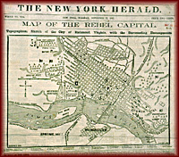
changed rapidly during the Civil War. To meet the military's
demand for maps of unfamiliar territory and troop movements,
cartographers embraced technologies that made their work more
accurate and that produced maps quickly for a wider
distribution. Army mapmakers used lithography Mapmaking
changed rapidly during the Civil War. To meet the military's
demand for maps of unfamiliar territory and troop movements,
cartographers embraced technologies that made their work more
accurate and that produced maps quickly for a wider
distribution. Army mapmakers used lithography
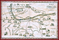 to produce maps quickly. They also embraced the new technology
of photography to reproduce maps. Army engineers increasingly
accepted standardized symbols to indicate natural features and
human settlements. By the late 1800s mapmakers had incorporated
scientific principles to create maps uniform in appearance.
to produce maps quickly. They also embraced the new technology
of photography to reproduce maps. Army engineers increasingly
accepted standardized symbols to indicate natural features and
human settlements. By the late 1800s mapmakers had incorporated
scientific principles to create maps uniform in appearance.
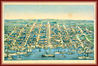 Beginning
in the 1850s, the use of lithography as an economical printing
technology served a growing middle class that clamored for
colorful images of cities or landmarks. Using an elevation or
bird's-eye view of a scene or city, such as the view of
Alexandria in 1862, artists and printmakers created a type of
map called the panoramic map to decorate private homes and
public buildings. In the 20th century, mapmakers and printers
took the bird's-eye view one step further by using photographic
techniques to map the landscape from airplanes and later from
satellites. Beginning
in the 1850s, the use of lithography as an economical printing
technology served a growing middle class that clamored for
colorful images of cities or landmarks. Using an elevation or
bird's-eye view of a scene or city, such as the view of
Alexandria in 1862, artists and printmakers created a type of
map called the panoramic map to decorate private homes and
public buildings. In the 20th century, mapmakers and printers
took the bird's-eye view one step further by using photographic
techniques to map the landscape from airplanes and later from
satellites.
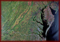
Computers now enable mapmakers to develop Geographic
Information Systems (GIS), which use a variety of methods to
create multiple geographic databases. Maps are used today to
plan urban development, to direct environmental projects, and to
document the impact of human activity on the land.
|
|
Mapping Virginia

Surveyors and Mapmakers
Mapping Technology
Vision of Empire
Building the
Commonwealth
The Geography of
Culture
Educators' Lesson Plans
|
