|
||
| Home >> Exhibitions >>The Common Wealth: Treasures from the Collections of the Library of Virginia >> Maps | ||
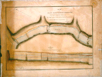
Claudius Crozet (1790-1864). A Plan of James Riv[er] from the North Branch to the balcony falls Exhibiting a comparison between the Pr. Engrs location & that substituted by the Commissioner, 1824. 13 x 18 1/4 inches. Among the many public works Virginia considered during the early 1800s was a canal to permit safe navigation through the Blue Ridge Mountains from the North Branch to Irish Falls in Rockbridge County. An act of the General Assembly on 8 May 1824 called on the "civil engineer of this State" to locate the canal "in such a manner as he may think best." In practice, the state's engineer worked with private companies on projects approved by the commonwealth's Board of Public Works. In this case, the board's principal engineer, Claudius Crozet, worked with the commissioner of the Kanawha Road and Navigation Company. Crozet had a distinguished career that began in Napoleon's army and lasted until his death in Virginia in 1864. In the second of two reports on the Blue Ridge canal project that Crozet submitted, he included this delicately drawn and colored map as well as diagrams prepared "with great care" from his own field book, "shewing the relative position and dimensions of both lines of canal." On the map, Crozet's plan is marked in red, the company commissioner's in yellow. Crozet included the diagrams to "present a comparative view of the quantity of excavation, walling, paving, etc. at each successive station." This is one of hundreds of unique maps in the Board of Public Works papers that document the development of Virginia's nineteenth-century transportation network. Many of the maps are also beautiful works of art. Location: Virginia Board of Public Works, Entry 495(23), Record Group 57 |