|
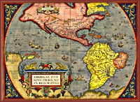 The
early maps of Virginia reflected the ideological perspectives of
their makers and users. They also served both as political and
as propaganda statements for the British, French, and Spanish
explorers intent on colonizing the North American continent.
Pamphlets, books, and engraved images encouraged settlement in
America. John Smith's map of Virginia, first published in 1612, The
early maps of Virginia reflected the ideological perspectives of
their makers and users. They also served both as political and
as propaganda statements for the British, French, and Spanish
explorers intent on colonizing the North American continent.
Pamphlets, books, and engraved images encouraged settlement in
America. John Smith's map of Virginia, first published in 1612,
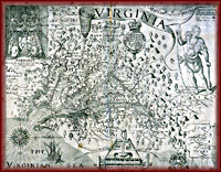 showed the new territory as a veritable Garden of Eden. In the
early years of settlement, maps of Virginia presented the colony
as though approached by the sea, with west at the top and north
to the right. These maps used information gained from both
American Indians and European explorers. The Appalachian
Mountains formed a major barrier to discovery of what lay
beyond. After explorers pushed past the mountains and mapmakers
visually described the new explorations Virginians recognized
the potential for trade, settlement, and mining.
showed the new territory as a veritable Garden of Eden. In the
early years of settlement, maps of Virginia presented the colony
as though approached by the sea, with west at the top and north
to the right. These maps used information gained from both
American Indians and European explorers. The Appalachian
Mountains formed a major barrier to discovery of what lay
beyond. After explorers pushed past the mountains and mapmakers
visually described the new explorations Virginians recognized
the potential for trade, settlement, and mining.
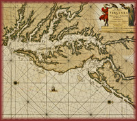 For
much of Virginia's early history, the Chesapeake Bay and its
coastal rivers were crucial to developing a trans-Atlantic trade
with Europe in tobacco and other agricultural products. Easy
access to the Chesapeake Bay or the Atlantic Ocean from the many
rivers hampered efforts to establish inland towns. The
scattershot pattern of houses dotting maps of colonial Virginia
reflects the relative ease with which farmers could transport
their hogsheads of tobacco to British ports. For
much of Virginia's early history, the Chesapeake Bay and its
coastal rivers were crucial to developing a trans-Atlantic trade
with Europe in tobacco and other agricultural products. Easy
access to the Chesapeake Bay or the Atlantic Ocean from the many
rivers hampered efforts to establish inland towns. The
scattershot pattern of houses dotting maps of colonial Virginia
reflects the relative ease with which farmers could transport
their hogsheads of tobacco to British ports.
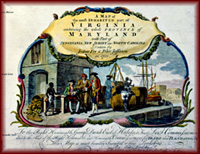
Expanding settlement of Virginia's interior produced demand
for land surveys and plans of towns. The number and variety of
maps thus formed a body of basic documents for mapmakers
interested in defining larger areas of the colony. Surveyors
such as Joshua Fry, Peter Jefferson, and John Henry made their
own surveys but also used existing maps to create large-scale
maps of the entire colony of Virginia.
 The
Fry-Jefferson map was the first map of the colony to show the
correct orientation of the Appalachian range through which ran
the Great Wagon Road that connected Philadelphia with North
Carolina. Having worked on surveys of both the Virginia-North
Carolina boundary and the boundaries of the Northern Neck
Proprietary, Joshua Fry and Peter Jefferson incorporated those
completed surveys into their map. Commissioned in 1750 by the
Board of Trade and Plantations in England, Fry and Jefferson
completed their map of the colony in 1751. The map was first
published in 1754 with an elaborate cartouche that emphasized
Virginia's dependence on a tobacco economy based on chattel
slavery. The
Fry-Jefferson map was the first map of the colony to show the
correct orientation of the Appalachian range through which ran
the Great Wagon Road that connected Philadelphia with North
Carolina. Having worked on surveys of both the Virginia-North
Carolina boundary and the boundaries of the Northern Neck
Proprietary, Joshua Fry and Peter Jefferson incorporated those
completed surveys into their map. Commissioned in 1750 by the
Board of Trade and Plantations in England, Fry and Jefferson
completed their map of the colony in 1751. The map was first
published in 1754 with an elaborate cartouche that emphasized
Virginia's dependence on a tobacco economy based on chattel
slavery.
Maps of Virginia during the mid-1700s expressed British
claims at the expense of competing French and Spanish claims. In
1755 John Mitchell published a large map of North America to
show where French and British claims overlapped. The American
and British diplomats consulted the map extensively to draw up
the 1783 Treaty of Paris that ended the Revolutionary War.
European countries expected the new United States of America to
stay within the treaty boundaries, but the new country intended
to push its boundaries deeper into the interior. Virginia's
claim to the West suggested a vision of an empire controlled by
the eastern states. |
|
Mapping Virginia

Surveyors and Mapmakers
Mapping Technology
Vision of Empire
Building the
Commonwealth
The Geography of
Culture
Educators' Lesson Plans
|
