

Maps and Formation Information for Accomack through Augusta Counties
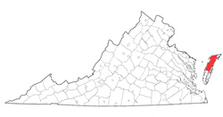 Accomack
County was named for the Accomac Indians, who lived on the eastern Shore
at the time of the first English settlement in Virginia. One of the
original eight shires established in 1634, Accomac County (spelled without
a k) became Northampton County in 1643. The present country was formed
from Northampton about 1663. In 1940 the General Assembly adopted the
county's present spelling. Its area is 476 square miles, and the county
seat is the town of Accomac. [Back]
Accomack
County was named for the Accomac Indians, who lived on the eastern Shore
at the time of the first English settlement in Virginia. One of the
original eight shires established in 1634, Accomac County (spelled without
a k) became Northampton County in 1643. The present country was formed
from Northampton about 1663. In 1940 the General Assembly adopted the
county's present spelling. Its area is 476 square miles, and the county
seat is the town of Accomac. [Back]
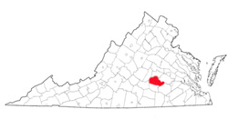
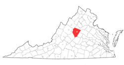 Albemarle
County was named for William Anne Keppel, second earl of
Albemarle and governor of the Virginia colony from 1737 to 1754.
It was formed from Goochland County in 1744, and part of Louisa
County and certain islands in the Fluvanna River, now called the
James, were added in 1761 and 1838. It area is 740 square miles, and the
county seat is Charlottesville. [Back]
Albemarle
County was named for William Anne Keppel, second earl of
Albemarle and governor of the Virginia colony from 1737 to 1754.
It was formed from Goochland County in 1744, and part of Louisa
County and certain islands in the Fluvanna River, now called the
James, were added in 1761 and 1838. It area is 740 square miles, and the
county seat is Charlottesville. [Back]
 Alexandria
County (extinct) was named for the town of Alexandria. It
was formed from a portion of Fairfax County that had been ceded
by Virginia in 1789 to the federal government for use as the site
of the national capital. In 1801, the area officially
became part of the District of Columbia, although Congress named
it Alexandria County. The county was returned to Virginia
in 1846, and in 1847 the General Assembly extended the
commonwealth's jurisdiction over the locality. In 1920, the
county name was changed to Arlington County. [Back]
Alexandria
County (extinct) was named for the town of Alexandria. It
was formed from a portion of Fairfax County that had been ceded
by Virginia in 1789 to the federal government for use as the site
of the national capital. In 1801, the area officially
became part of the District of Columbia, although Congress named
it Alexandria County. The county was returned to Virginia
in 1846, and in 1847 the General Assembly extended the
commonwealth's jurisdiction over the locality. In 1920, the
county name was changed to Arlington County. [Back]
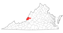 Alleghany
County was named for the Allegheny Mountains, although it has a
variant spelling. It was formed from Bath, Botetourt, and Monroe
(West Virginia) Counties in 1822, and additional parts of
Bath (1823) and Monroe (1843) were added. It area is 444 square miles,
and the county seat is Covington. The former independent city of Clifton
Forge reverted to the county in 2001. [Back]
Alleghany
County was named for the Allegheny Mountains, although it has a
variant spelling. It was formed from Bath, Botetourt, and Monroe
(West Virginia) Counties in 1822, and additional parts of
Bath (1823) and Monroe (1843) were added. It area is 444 square miles,
and the county seat is Covington. The former independent city of Clifton
Forge reverted to the county in 2001. [Back]
 Amelia
County was named for Amelia Sophia Eleanora, daughter of George
II of England. It was formed from Prince George and
Brunswick Counties in 1734. Its area is 366 square miles
and the county seat is Amelia. [Back]
Amelia
County was named for Amelia Sophia Eleanora, daughter of George
II of England. It was formed from Prince George and
Brunswick Counties in 1734. Its area is 366 square miles
and the county seat is Amelia. [Back]
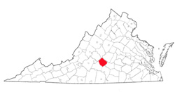
 Amherst
County was named for Major Jeffery Amherst, British commander in
North America during the French and Indian War and governor of
Virginia from 1759 to 1768. It was formed from Albemarle
County in 1761. Its area is 470 square miles, and the
county seat is Amherst. [Back]
Amherst
County was named for Major Jeffery Amherst, British commander in
North America during the French and Indian War and governor of
Virginia from 1759 to 1768. It was formed from Albemarle
County in 1761. Its area is 470 square miles, and the
county seat is Amherst. [Back]
 Appomattox
County was named for the Appomattox River, which rises in the
county. The name was borne earlier by an Indian tribe
living near the mouth of the river. The county was formed
from parts of Buckingham, Prince Edward, Charlotte and Campbell
Counties in 1845, and another part of Campbell was added in 1858.
Its area is 345 square miles, and the county seat is Appomattox. [Back]
Appomattox
County was named for the Appomattox River, which rises in the
county. The name was borne earlier by an Indian tribe
living near the mouth of the river. The county was formed
from parts of Buckingham, Prince Edward, Charlotte and Campbell
Counties in 1845, and another part of Campbell was added in 1858.
Its area is 345 square miles, and the county seat is Appomattox. [Back]
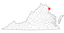
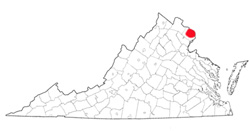 Arlington
County was originally named Alexandria County. It was formed from a
part of Fairfax County that was ceded to the U.S. government in 1789 but
was returned to Virginia in 1846. The county name was changed in
1920 to Arlington, the name of the Custis family mansion (former home of
Robert E. Lee), which is located in the county. Its area is 25
square miles, and the county seat is Arlington. [Back]
Arlington
County was originally named Alexandria County. It was formed from a
part of Fairfax County that was ceded to the U.S. government in 1789 but
was returned to Virginia in 1846. The county name was changed in
1920 to Arlington, the name of the Custis family mansion (former home of
Robert E. Lee), which is located in the county. Its area is 25
square miles, and the county seat is Arlington. [Back]
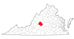
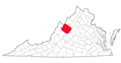 Augusta
County was named in honor of Augusta of Saxe-Gotha, wife of Frederick
Louis, Prince of Wales, and mother of George III. It was formed from
Orange County in 1738, but county government was not established there
until 1745. Its area is 968 square miles, and the county seat is
Staunton. [Back]
Augusta
County was named in honor of Augusta of Saxe-Gotha, wife of Frederick
Louis, Prince of Wales, and mother of George III. It was formed from
Orange County in 1738, but county government was not established there
until 1745. Its area is 968 square miles, and the county seat is
Staunton. [Back]
