

Maps and Formation Information for Campbell through Cumberland Counties
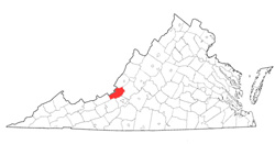
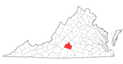 Campbell
County was named for William Campbell, one of the heroes of the Battle of
Kings Mountain in 1780. The county was formed from Bedford County in
1781. Its area is 511 square miles, and the county seat is Rustburg.
[Back]
Campbell
County was named for William Campbell, one of the heroes of the Battle of
Kings Mountain in 1780. The county was formed from Bedford County in
1781. Its area is 511 square miles, and the county seat is Rustburg.
[Back]
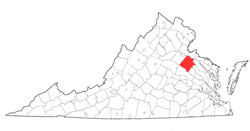 Caroline
County was named for Caroline of Anspach, consort of George II.
It was formed from Essex, King and Queen, and King William
Counties in 1728, and additional parts of King and Queen were
added in
1742 and 1762. Its area is 549 square miles, and the county
seat is Bowling Green. [Back]
Caroline
County was named for Caroline of Anspach, consort of George II.
It was formed from Essex, King and Queen, and King William
Counties in 1728, and additional parts of King and Queen were
added in
1742 and 1762. Its area is 549 square miles, and the county
seat is Bowling Green. [Back]
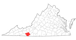 Carroll
County was named for Charles Carroll of Carrollton, a signer of
the Declaration of Independence from Maryland. It was
formed from Grayson County in 1842, and part of Patrick County
was added in 1856. Its area is 497 square miles, and the
county seat is Hillsville. [Back]
Carroll
County was named for Charles Carroll of Carrollton, a signer of
the Declaration of Independence from Maryland. It was
formed from Grayson County in 1842, and part of Patrick County
was added in 1856. Its area is 497 square miles, and the
county seat is Hillsville. [Back]
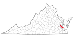
 Charles
City County was named for Charles I of England and was one of the
eight shires established in 1634. Its area is 204 square
miles, and the county seat is Charles City. [Back]
Charles
City County was named for Charles I of England and was one of the
eight shires established in 1634. Its area is 204 square
miles, and the county seat is Charles City. [Back]
 Charles
River County was named for Charles I of England and was one of
the eight shires established in 1634. It was renamed York
County in 1643, probably in honor of James, duke of York, the
second son of Charles I. See York County. [Back]
Charles
River County was named for Charles I of England and was one of
the eight shires established in 1634. It was renamed York
County in 1643, probably in honor of James, duke of York, the
second son of Charles I. See York County. [Back]
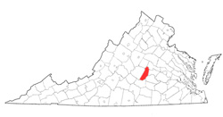
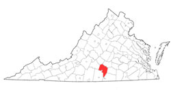 Charlotte
County was named for Charlotte of Mecklenburg-Strelitz, consort
of George III. It was formed from Lunenburg County in 1764.
Its area is 471 square miles, and the county seat is Charlotte
Court House. [Back]
Charlotte
County was named for Charlotte of Mecklenburg-Strelitz, consort
of George III. It was formed from Lunenburg County in 1764.
Its area is 471 square miles, and the county seat is Charlotte
Court House. [Back]
 Chesterfield
County was named for Philip Dormer Stanhope, fourth earl of
Chesterfield, British statesman and diplomat, and was formed from
Henrico County in 1749. Its area is 446 square miles, and
the county seat is Chesterfield.
[Back]
Chesterfield
County was named for Philip Dormer Stanhope, fourth earl of
Chesterfield, British statesman and diplomat, and was formed from
Henrico County in 1749. Its area is 446 square miles, and
the county seat is Chesterfield.
[Back]
 Clarke
County was named for George Rogers Clark (spelled without an e),
who helped win the Northwest Territory for Virginia during the Revolution. The county was formed from Frederick County in
1836, and part of Warren County was added in 1860. Its area is 174
square miles, and the county seat is Berryville. [Back]
Clarke
County was named for George Rogers Clark (spelled without an e),
who helped win the Northwest Territory for Virginia during the Revolution. The county was formed from Frederick County in
1836, and part of Warren County was added in 1860. Its area is 174
square miles, and the county seat is Berryville. [Back]
 Craig
County was named for Robert Craig, a nineteenth-century Virginia
congressman. The county was formed from Botetourt, Roanoke, Giles,
and Monroe (West Virginia) Counties in 1851. Parts of Monroe County
were added in 1853 and 1856, part of Montgomery County was added in 1853,
part of Alleghany County added in 1856, and part of Giles County added in
1858. Its area is 336 square miles, and the county seat is New
Castle. [Back]
Craig
County was named for Robert Craig, a nineteenth-century Virginia
congressman. The county was formed from Botetourt, Roanoke, Giles,
and Monroe (West Virginia) Counties in 1851. Parts of Monroe County
were added in 1853 and 1856, part of Montgomery County was added in 1853,
part of Alleghany County added in 1856, and part of Giles County added in
1858. Its area is 336 square miles, and the county seat is New
Castle. [Back]
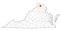
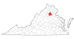 Culpeper
County probably was name for Catherine Culpeper, or for her mother,
Margaret Lady Culpeper, or for Thomas Culpeper, second baron Culpeper of
Thoresway, governor of Virginia from 1677 to 1683, or for their family,
which long held proprietary right in the Northern Neck. It was
formed from Orange County in 1749. Its area is 389 square miles, and
the county seat is Culpeper. [Back]
Culpeper
County probably was name for Catherine Culpeper, or for her mother,
Margaret Lady Culpeper, or for Thomas Culpeper, second baron Culpeper of
Thoresway, governor of Virginia from 1677 to 1683, or for their family,
which long held proprietary right in the Northern Neck. It was
formed from Orange County in 1749. Its area is 389 square miles, and
the county seat is Culpeper. [Back]
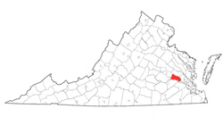
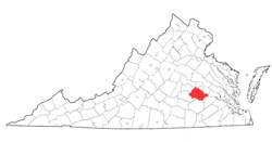
 Cumberland
County was named for William Augustus, duke of Cumberland, third son of
George II. It was formed from Goochland County in 1749. Its
area is 298 square miles, and the county seat is Cumberland. [Back]
Cumberland
County was named for William Augustus, duke of Cumberland, third son of
George II. It was formed from Goochland County in 1749. Its
area is 298 square miles, and the county seat is Cumberland. [Back]
