

Maps and Formation Information for Dickenson through Essex Counties
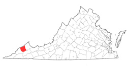 Dickenson
County was named for William J. Dickenson, delegate to the General
Assembly from Russell County in 1880 when Dickenson was formed from Wise,
Russell, and Buchanan Counties. Its area is 355 square miles, and
its county seat is Clintwood. [Back]
Dickenson
County was named for William J. Dickenson, delegate to the General
Assembly from Russell County in 1880 when Dickenson was formed from Wise,
Russell, and Buchanan Counties. Its area is 355 square miles, and
its county seat is Clintwood. [Back]
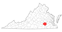 Dinwiddie
County was named for Robert Dinwiddie, lieutenant governor of
Virginia from 1751 to 1758. The county was formed from
Prince George County in 1752. Its area is 501.28 square
miles, and the county seat is Dinwiddie. [Back]
Dinwiddie
County was named for Robert Dinwiddie, lieutenant governor of
Virginia from 1751 to 1758. The county was formed from
Prince George County in 1752. Its area is 501.28 square
miles, and the county seat is Dinwiddie. [Back]
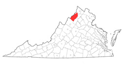 Dunmore
County was named for John Murray, fourth earl of Dunmore and
governor of Virginia from 1771 to 1775. It was formed from
Frederick County in May 1772. Dunmore's loyalty to the
crown at the outbreak of the American Revolution made him
unpopular with Virginians, so the General Assembly changed the
county's name to Shanando (now Shenandoah) County, effective 1
February 1778. See Shenandoah County. [Back]
Dunmore
County was named for John Murray, fourth earl of Dunmore and
governor of Virginia from 1771 to 1775. It was formed from
Frederick County in May 1772. Dunmore's loyalty to the
crown at the outbreak of the American Revolution made him
unpopular with Virginians, so the General Assembly changed the
county's name to Shanando (now Shenandoah) County, effective 1
February 1778. See Shenandoah County. [Back]
 Elizabeth
City County (extinct) was named for Elizabeth, daughter of James
I, and was one of the eight shires established in 1634. It
became extinct in 1952, when it was incorporated into the city of
Hampton, which was the county seat. See City of Hampton. [Back]
Elizabeth
City County (extinct) was named for Elizabeth, daughter of James
I, and was one of the eight shires established in 1634. It
became extinct in 1952, when it was incorporated into the city of
Hampton, which was the county seat. See City of Hampton. [Back]
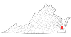
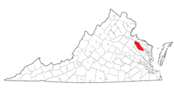 Essex County was named for the English
county. It was formed from old Rappahannock County in 1692.
Its area is 261 square miles, and the county seat is
Tappahannock. [Back]
Essex County was named for the English
county. It was formed from old Rappahannock County in 1692.
Its area is 261 square miles, and the county seat is
Tappahannock. [Back]
