

Maps and Formation Information for Tazewell through York Counties
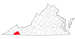
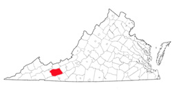
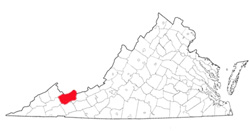 Tazewell
County was named for Henry Tazewell, U.S. senator from Virginia from 1794
until his death in 1799. It was formed from Wythe and Russell
Counties in 1799. Parts of Russell County were added in 1807 and
1835, parts of Washington and Wythe Counties were added in 1826, and part
of Logan County (West Virginia) was added in 1834. Its area is 522
square miles, and the county seat is Tazewell. [Back]
Tazewell
County was named for Henry Tazewell, U.S. senator from Virginia from 1794
until his death in 1799. It was formed from Wythe and Russell
Counties in 1799. Parts of Russell County were added in 1807 and
1835, parts of Washington and Wythe Counties were added in 1826, and part
of Logan County (West Virginia) was added in 1834. Its area is 522
square miles, and the county seat is Tazewell. [Back]
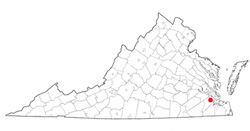
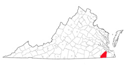 Upper
Norfolk County was established in 1637. In 1646, it was
renamed Nansemond County for the area's Nansemond Indians.
The county seat was Suffolk. The county became the
independent city of Nansemond in 1972, and in 1974, Nansemond
merged with the city of Suffolk. The entire area is now
known as Suffolk. [Back]
Upper
Norfolk County was established in 1637. In 1646, it was
renamed Nansemond County for the area's Nansemond Indians.
The county seat was Suffolk. The county became the
independent city of Nansemond in 1972, and in 1974, Nansemond
merged with the city of Suffolk. The entire area is now
known as Suffolk. [Back]
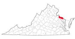
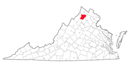 Warren
County was named for Joseph Warren, the revolutionary patriot who
sent Paul Revere and William Dawes on their famous rides and who
was killed at the Battle of Bunker Hill. The county was
formed from Frederick and Shenandoah counties in 1836. Its
area is 214 square miles, and the county seat is Front Royal. [Back]
Warren
County was named for Joseph Warren, the revolutionary patriot who
sent Paul Revere and William Dawes on their famous rides and who
was killed at the Battle of Bunker Hill. The county was
formed from Frederick and Shenandoah counties in 1836. Its
area is 214 square miles, and the county seat is Front Royal. [Back]
 Warrosquyoake
County was named for the Indian tribe. It was formed in
1634 as one of the original eight shires. In 1637 it was
renamed Isle of Wight County. [Back]
Warrosquyoake
County was named for the Indian tribe. It was formed in
1634 as one of the original eight shires. In 1637 it was
renamed Isle of Wight County. [Back]
 Warwick
County was originally called Warwick River County when it was
formed as one of the original eight shires in 1634. The
shorter name was adopted in 1643. It was named either for
Robert Rich, earl of Warwick, a prominent member of the London
Company, or for the county of Warwick in England. Warwick
County became extinct in 1952, when it became the city of
Warwick. The new city was consolidated with the city of
Newport News in 1958 and took the latter's name. Denbigh
was the county seat. [Back]
Warwick
County was originally called Warwick River County when it was
formed as one of the original eight shires in 1634. The
shorter name was adopted in 1643. It was named either for
Robert Rich, earl of Warwick, a prominent member of the London
Company, or for the county of Warwick in England. Warwick
County became extinct in 1952, when it became the city of
Warwick. The new city was consolidated with the city of
Newport News in 1958 and took the latter's name. Denbigh
was the county seat. [Back]
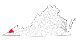
 Washington
County is the first locality in the United States known to have
been named for George Washington. It was formed from
Fincastle County in 1776, and a part of Montgomery County was
added in 1777. Its area is 563 square miles, and the county
seat is Abingdon. [Back]
Washington
County is the first locality in the United States known to have
been named for George Washington. It was formed from
Fincastle County in 1776, and a part of Montgomery County was
added in 1777. Its area is 563 square miles, and the county
seat is Abingdon. [Back]
 Westmoreland
County was named for the English county. It was formed from
Northumberland County in 1653, and part of King George County was added in
1777. Its area is 229 square miles, and the county seat is Montross.
[Back]
Westmoreland
County was named for the English county. It was formed from
Northumberland County in 1653, and part of King George County was added in
1777. Its area is 229 square miles, and the county seat is Montross.
[Back]
 Wise
County was named for Henry Alexander Wise, governor of Virginia from 1856
to 1860. It was formed in 1856 from Lee, Scott, and Russell
Counties. Its area is 404 square miles, and the county seat is Wise. [Back]
Wise
County was named for Henry Alexander Wise, governor of Virginia from 1856
to 1860. It was formed in 1856 from Lee, Scott, and Russell
Counties. Its area is 404 square miles, and the county seat is Wise. [Back]
 Wythe
County was named for George Wythe, a signer of the Declaration of
Independence and chancellor of Virginia in 1789 when Wythe County was
formed from Montgomery County. Part of Grayson County was added in
1825. Its area is 463 square miles, and the county seat is
Wytheville. [Back]
Wythe
County was named for George Wythe, a signer of the Declaration of
Independence and chancellor of Virginia in 1789 when Wythe County was
formed from Montgomery County. Part of Grayson County was added in
1825. Its area is 463 square miles, and the county seat is
Wytheville. [Back]
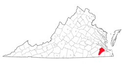
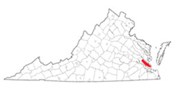 York
County was originally named Charles River County, for Charles I, and was
one of the eight shires formed in 1634. The present name was given
in 1643, probably in honor of James, duke of York, the second son of
Charles I. Its area is 106 square miles, and the county seat is
Yorktown. [Back]
York
County was originally named Charles River County, for Charles I, and was
one of the eight shires formed in 1634. The present name was given
in 1643, probably in honor of James, duke of York, the second son of
Charles I. Its area is 106 square miles, and the county seat is
Yorktown. [Back]
