

Maps and Formation Information for Nansemond through Nottoway Counties
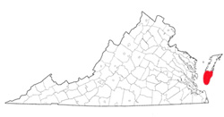
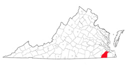 Nansemond
County (extinct) was named for the Nansemond Indians, who lived in the
area in the early seventeenth century. The word nansemond
means fishing point or angle. When first established in 1637, the
county was known as Upper Norfolk, but the name Nansemond was adopted in
1646. The county seat was Suffolk. The county became the
independent city of Nansemond in July 1972, and on 1 January 1974
Nansemond merged with the city of Suffolk. The entire area is now
known as Suffolk. See Suffolk. [Back]
Nansemond
County (extinct) was named for the Nansemond Indians, who lived in the
area in the early seventeenth century. The word nansemond
means fishing point or angle. When first established in 1637, the
county was known as Upper Norfolk, but the name Nansemond was adopted in
1646. The county seat was Suffolk. The county became the
independent city of Nansemond in July 1972, and on 1 January 1974
Nansemond merged with the city of Suffolk. The entire area is now
known as Suffolk. See Suffolk. [Back]
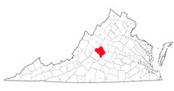 Nelson
County was named for Thomas Nelson, Jr., governor of Virginia
from June to November 1781. It was formed in 1807 from
Amherst County. Its area is 471 square miles, and the
county seat is Lovington. [Back]
Nelson
County was named for Thomas Nelson, Jr., governor of Virginia
from June to November 1781. It was formed in 1807 from
Amherst County. Its area is 471 square miles, and the
county seat is Lovington. [Back]
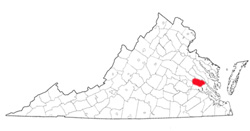 New
Kent County was named either for the English county of Kent or
for Kent Island, in the upper waters of the Chesapeake Bay.
William Claiborne, a native of Kent who had been driven from Kent
Island by Lord Baltimore, was a prominent resident of the New
Kent area about 1654 when the county was formed from York County.
Its area is 221 square miles, and the county seat is New Kent.
[Back]
New
Kent County was named either for the English county of Kent or
for Kent Island, in the upper waters of the Chesapeake Bay.
William Claiborne, a native of Kent who had been driven from Kent
Island by Lord Baltimore, was a prominent resident of the New
Kent area about 1654 when the county was formed from York County.
Its area is 221 square miles, and the county seat is New Kent.
[Back]
 New
Norfolk County (extinct) was named by Charles I and was created
from Elizabeth City County in 1636. It became extinct when
it was divided into Upper and Lower Norfolk counties in 1637.
See Nansemond County; Norfolk County. [Back]
New
Norfolk County (extinct) was named by Charles I and was created
from Elizabeth City County in 1636. It became extinct when
it was divided into Upper and Lower Norfolk counties in 1637.
See Nansemond County; Norfolk County. [Back]
 Norfolk
County (extinct) probably was named by Adam Thoroughgood, a local
resident, from his native county in England. It was formed
from Lower Norfolk County in 1691. Norfolk County became
extinct in 1963, when it was consolidated with the city of South
Norfolk to form the city of Chesapeake. The county seat was
Portsmouth. See Chesapeake. [Back]
Norfolk
County (extinct) probably was named by Adam Thoroughgood, a local
resident, from his native county in England. It was formed
from Lower Norfolk County in 1691. Norfolk County became
extinct in 1963, when it was consolidated with the city of South
Norfolk to form the city of Chesapeake. The county seat was
Portsmouth. See Chesapeake. [Back]
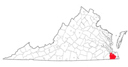
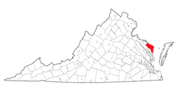
 Northampton
County probably was named for the English county, of which
Obedience Robins, a prominent early resident of the Eastern
Shore, was a native. The county, which originally included
all of the peninsula south of Maryland and which was one of the
eight shires established in 1694, was first called Accomac.
The name was changed by legislative action in 1643. The
area is 357 square miles, and the county seat is Eastville.
[Back]
Northampton
County probably was named for the English county, of which
Obedience Robins, a prominent early resident of the Eastern
Shore, was a native. The county, which originally included
all of the peninsula south of Maryland and which was one of the
eight shires established in 1694, was first called Accomac.
The name was changed by legislative action in 1643. The
area is 357 square miles, and the county seat is Eastville.
[Back]
 Northumberland
County probably was named for the English county. It was
formed about 1645 from the district of Chickacoan, the
early-seventeenth-century name for the region between the Potomac
and the Rappahannock rivers. Its area is 223 square miles,
and the county seat is Heathsville. [Back]
Northumberland
County probably was named for the English county. It was
formed about 1645 from the district of Chickacoan, the
early-seventeenth-century name for the region between the Potomac
and the Rappahannock rivers. Its area is 223 square miles,
and the county seat is Heathsville. [Back]
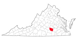 Nottoway
County was named for the Nadowa Indian tribe. The word nadowa,
anglicized to nottoway, means snake, or enemy. The county was
formed from Amelia County in 1788. Its area is 308 square miles, and
the county seat is Nottoway. [Back]
Nottoway
County was named for the Nadowa Indian tribe. The word nadowa,
anglicized to nottoway, means snake, or enemy. The county was
formed from Amelia County in 1788. Its area is 308 square miles, and
the county seat is Nottoway. [Back]
