Image

The Map Collection Index covers a core collection of about 7,000 maps. The core collection consists of manuscript and printed maps and photocopies of general historical maps and special groups of maps such as the Alan M. Voorhees Map Collection, Board of Public Works maps, Civil War maps, and Chesapeake and Ohio Company railroad maps. The U.S.G.S. topographic maps and the collection of drawings and plans are not covered by this index.
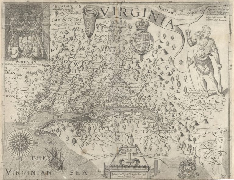
Many of the 17th and 18th century maps in the collection are printed maps that appeared in atlases. In addition to the John Smith map of 1612, important Virginia maps include the Augustine Hermann map (1673), the Fry-Jefferson map (1751/1754, 1755 and 1775), the John Henry map (1770), the Bishop Madison map (1807) and the state maps of 1827 and 1859 produced by the Virginia Board of Public Works. The collection also includes the 1819 copperplate used in the reprint of John Smith's Generall Historie of Virginia as well as eight of the nine original copperplates for the 1827/1859 state map.
The Board of Public Works maps consist of more than 500 titles (900 sheets) of surveys and maps, primarily manuscript, generated in the development of turnpikes, canals and railroads. This collection also includes the county maps created by John Wood and Herman Boye between 1819 and 1825. There are 275 maps, charts and plans, (1,800 sheets) in the Chesapeake and Ohio Map Collection from 1836-1943. These maps depict the railroad routes along the James River and Kanawha Canal towpaths; surveys of routes through the towns of Charlottesville, Lynchburg, Richmond and Hampton; plats of railroad depots and private property condemned for use by the railroad; and surveys of branch line routes.
This is not an alphabetic index. General arrangement is by larger geographic area followed by smaller geographic areas. Virginia maps are arranged by regions of the state followed by political subdivisions within each region. Arrangement is east to west across the state or region. Maps within the same geographic area are arranged by date followed by a limited subject file pertaining to that area. See Detailed Arrangement below. Cards contain a description of the map and the classification number of the map. This is a difficult finding aid to use. Please do not hesitate to ask Library staff for assistance.
The index is generally arranged geographically from east to west. Arrangement is by larger geographic area followed by smaller geographic areas. Maps of Virginia are arranged by date followed by a subject file arranged alphabetically from Agriculture to Traffic Flow.
Regional maps of Virginia follow maps which cover the entire state. The major regions listed in the index are:
The regions are subarranged by counties and cities. For example:
Please note that the online index does not show indentations.
The titles listed in the map collection index are being added to the online catalog. Currently, all titles filed under Virginia and West Virginia are in the online catalog. Titles from the following regions and counties have been added to the online catalog: Eastern Virginia, Northampton, Accomack, Chesapeake Bay, Northern Neck, and Henrico County. Many maps have been digitized. Please explore these digital collections:
The index is generally arranged geographically from east to west. Arrangement is by larger geographic area followed by smaller geographic areas. Maps of Virginia are arranged by date followed by a subject file arranged alphabetically from Agriculture to Traffic Flow. Click on the index point closest to the item being searched.
Country
Region
States
Virginia
Regions
Counties and Cities